
So, I promised I'd write about Anchorage's "grid" "system". Like all sensible cities (i.e. not Boston or Providence), Anchorage is laid out as a grid of numbered avenues and lettered streets. So if you wanted to do something like drive from O Street & 15th Ave to O Street & 7th Ave, you should just be able to drive down O Street for 8 blocks, right?
HA!
Here's what you actually have to do: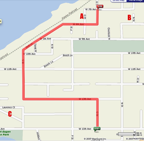
The grid, as you can see, is broken up pretty much all over the place, and that combined with all the one-way streets means that you actually have to Mapquest things like "O St & 15th Ave to O St & 7th Ave". Additional points of interest on the above map:
A) Note that this is O Place, as opposed to O Street.
B) This tiny nub of N Street doesn't even line up with the rest of N Street. According to the street-naming conceit in Galveston, TX, this would make it "M 1/2 Street". Which would be awesome.
C) Our house! Hi!
Here are a couple other nice driving situations, both within 8 blocks of our house. God only knows what's going on in the rest of this city.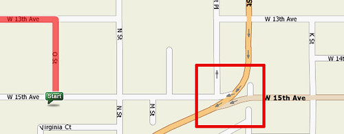
The above image shows what you must contend with if you're heading west on 15th Ave. You're bopping along from K Street, hoping to get to M Street, when WHOA WHAT you find that you're being forced onto Minnesota Street! If you want to get to M and 15th, silly, you have to turn right on K, left on 13th, left on L, and then right onto a street which looks like a bike path but which is actually 15th Ave. Once you've passed K on 15th, you have no choice but to get on Minnesota and go up half a mile until you can turn around. The best part, though, is that once you've turned around and you get off Minnesota, the first intersection is 15th, and if you turn left on 15th, you end up right back on Minnesota again! Not that I've ever done that.
Next: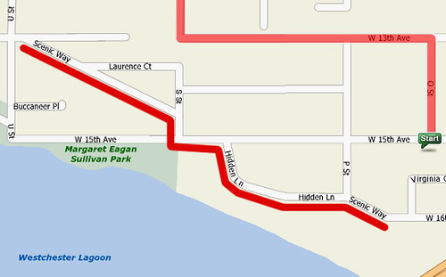
Above, you will see what you have to do to get from 1600 Scenic Way to 1700 Scenic Way. It's not so much that there are two sections of Scenic Way that aren't connected -- it's just that Scenic Way becomes a completely different street, and then a second completely different street, before it changes back to Scenic Way. I think it's called Hidden Lane because Scenic Way is hidden underneath it or something.
Anyway, it was hard to adjust at first, but once you know you have to get directions for pretty much any trip between two points, you learn to live with it.
Wednesday, July 4, 2007
Off the Grid
![]()
Subscribe to:
Post Comments (Atom)
1 comment:
I concede the argument right away between San Diego and Anchorage, because Anchorage is clearly more insane.
However, just to put San Diego into the debate, a few brief remarks.
* Never, ever , ever assume that any two streets with the same name will link. for example, I leave near Upas St. Upas st. has no fewer than four iterations, each broken up by an intervening canyon or tall hill.
* never assume you can make a left on broadway. Broadway is merely the main drag downtown. it runs east west, but if you're driving east want to go north, you pretty much have to drive all the way through downtown to get to a cross street with no "No left turn" sign at it. Bear in mind, you must stop at every light and wait, as you fume.
* On the up side, no mechanism for naming streets has gone unused, and the themes tell you what neighborhood you're in. If you're in lettered and numbered streets, you're downtown or in southeast San Diego. If the streets are named for birds, you're in Mission Hills. trees=Hillcrest. precious and semi-precious stones = Pacific Beach, Presidents = Normal Heights and University Heights, if every street has the words "La Jolla" in the name(La Jolla Village Drive, La Jolla parkway, La Jolla Shores Drive, etc.), you're in La Jolla. Get it? Good.
Fortunately everything makes enough sense that I can memorize chunks of it and fit in the rest with a little Google maps help. It's never as zany as what you describe.
Post a Comment